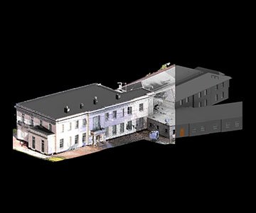
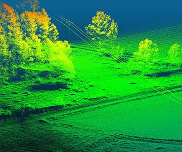
3D laser scanning is used to capture existing site conditions with high accuracy.
It supports as-built documentation, BIM modelling, CAD drafting, renovation planning,
reverse engineering, and project coordination.
3D Laser Scanning
Learn more about our 3D laser scanning, LiDAR surveying, BIM modelling,
GIS mapping, and engineering data solutions designed for accurate project delivery.
3D Laser Scanning
About the service
Our 3D laser scanning service captures highly accurate spatial data from buildings, industrial facilities, infrastructure sites, and existing assets. This helps create reliable digital references for planning, design, renovation, documentation, and engineering coordination.
Using advanced scanning workflows, Fotios converts real-world conditions into detailed point cloud data that can support BIM modelling, CAD drafting, as-built documentation, reverse engineering, and GIS-based project analysis.
Why choose us
We focus on accuracy, structured workflows, timely delivery, and dependable engineering outputs. Our team works closely with project requirements to ensure the captured data is useful, organized, and ready for practical use in the next stages of the project.
01
Accuracy
We deliver precise reality capture outputs that support dependable engineering and documentation workflows.
02
Technical Expertise
Our team works with point clouds, BIM, CAD, GIS, and scan-based deliverables for multiple project needs.
03
Efficient Workflow
We follow organized digital workflows that reduce delays and improve clarity across project stages.
04
Reliable Delivery
We focus on quality checks, structured outputs, and practical data usage for engineering teams.
Services offered
- 3D Laser Scanning: We capture detailed and accurate spatial information from buildings, plants, equipment areas, and infrastructure environments.
- Point Cloud Processing: We process raw scan data into clean, structured, and usable point cloud outputs for modelling, drafting, and documentation.
- Scan to BIM & CAD: We convert scan data into BIM models, CAD drawings, and as-built documentation that support planning and execution workflows.
-
What is 3D laser scanning used for?
-
What deliverables can be created from scan data?Depending on the project, scan data can be converted into point clouds, BIM models, Revit files, CAD drawings, 2D plans, elevations, sections, GIS datasets, and digital engineering documentation.
-
How long does a typical scan-based project take?Project timelines depend on site size, complexity, access conditions, and the required deliverables. Smaller projects may take a few days, while larger modelling and documentation assignments may take several weeks.
-
Can you convert old drawings or PDFs into BIM models?Yes, we can help convert CAD files, legacy drawings, PDFs, and scan-based data into BIM-ready and structured engineering deliverables based on project requirements.
-
Which industries benefit from these services?Our services are useful for buildings, industrial facilities, infrastructure, renovation projects, plant engineering, utilities, and any project that requires accurate digital documentation of existing conditions.
-
How can I start a project with Fotios?You can contact our team with your project scope, location, existing drawings, required outputs, and timeline. Based on this, we can suggest the most suitable workflow and service approach.